Thursday 26 April 2012

Cape Pembroke

Wednesday, 25th April 2012. The James Clark Ross is still moored up at FIPASS docks in Stanley, after returning from a month-long science cruise to the Southern Ocean. After more packing and post-cruise tidying up, a small weather window opened to go and explore the Falkland Islands. On our previous visit to the area I had explored the Cape Pembroke/Stanley Common area to visit Gypsy Cove and its colony of Magellanic penguins. So this time round I decided to take a slightly different route and make it all the way to Cape Pembroke and its picturesque black and white lighthouse, that our ship had sailed past only yesterday.

Whalebone Cove and Stanley in the background
The walk took me on initially familiar terrain out towards the small out of town airport. From higher ground I had a fabulous view over Whalebone Cove with the wreck of the Lady Elizabeth, and our vessel the James Clark Ross could be seen in the distance. What a contrast those two make - a shiny, modern research vessel and a rusting old ghost ship. The airport seemed to consist of only a small landing strip and some storage and terminal buildings. Most air traffic now uses the Mount Pleasant airport, so this airfield is only used by the inter-island flights using smaller planes.

I walked further east on what looked like a path with deep wheel ruts carved by 4x4 offroaders. And lo and behold, I came across a Landrover coming the other way. Why not, I thought - it's a perfectly pleasant afternoon. But surely, a walk in this beautiful countryside must be more rewarding than driving through it and leaving deep scars in the landscape. Little did I realise how ridiculous this little trip in the offroader actually was, until I spotted a dog running just behind. It had seen me and immediately started approaching when the lady repeatedly called her dog back from within the car. This woman was actually walking her dog from inside the car with the windows wound down. Phew - only in the Falklands!

Upland geese in a mine field
A little further on the path followed to the right of a barbed wire fence. It marked the boundary of various mine fields which means the penguin colonies on the beach are strictly off-limits to humans. The terms of surrender that ended the 1982 war stated that the Argentinians had to reveal the locations of all their mine fields. They did indeed point out which areas had been mined but they hadn't made or didn't leave any records of individual mines. After the war the clearing effort concentrated on more important areas than penguin colonies and the mines were left in place here. It's perfect protection for breeding seabirds, and as far as I am concerned it's OK to just leave things as they are. Tourists and locals don't really need unrestricted access to every penguin colony, do they? The marked paths and installed walkways and viewing platforms make Gypsy Cove very accessible, so it's nice to see that these nearby colonies are still behind barbed wire.


Looking out to see I spotted a pod of dolphins just infront of the Tussock Islands. Four or five animals repeatedly surfaced. Were they feeding? I don't know...


The Cape Pembroke lighthouse
Cape Pembroke is the site of a historic lighthouse with its characteristic black and white colour scheme. It had been operational until the 1982 war, when it was turned off in light of the heavy fighting around Stanley. After the war it remained shut and there is now a beacon that points out the cape to passing shipping. Unfortunately the lighthouse is closed to visitors, and the key is with the museum in town. So I didn't have the opportunity to go to the top - the view would surely have been stunning from the higher vantage point.

The MV Atlantic Coveyor memorial at Cape Pembroke
Near the lighthouse is a war memorial to 12 men of the MV Atlantic Conveyor who died on 25 May 1982 out at sea 90 miles from the memorial in shape of a large propeller.


View out to sea from Cape Pembroke

On the way back from Cape Pembroke along Stanley Bypass I found a large post festooned with signposts to the most obscure places on the planet. The selection of places included someone favourite football stadium, and lots of small and big towns and cities. The closest to Plymouth I could find was a sign pointing towards the Tamar valley in Cornwall at a distance of 7770 miles. Oban in Scotland was marked as being 15113 miles away - the long way around!

If I ever come here again I must remember to bring not only a poppy, but also a signpost with the distance to whereever I happen to be living at that time. Watch this post.. who knows when I'll be back. In the Falkland Islands. It's a wonderful place. And I'll try to stay longer next time...

Next stop Ascension Island. The journey home has begun.

Day 29 Arrival in the Falklands

Dolphins escort us back to the Falklands
Tuesday, 24th April 2012. This is the day 29 of our Southern Ocean cruise to the Weddell Sea, the Scotia Sea and South Georgia. After nearly a month at sea the James Clark Ross is within sight of the Falkland Islands again. For us scientists returning to the Falklands means the end of the cruise, but for many on board it meant to come home. Several crew members had grown up here, or had family or friends on the islands. It would also be a homecoming for the JCR, which is registered in Stanley. The ship was also coming to her home port.

Just as we came closer and closer to land a pod of dolphins gave us a welcome escort on our portside. It was great to see Commerson's dolphins again. A month ago we had seen them feeding in the surf at Bertha's beach whilst the ship was waiting to be mobilised at Mare Habour. Now it felt like they were welcoming us back again.

Passing Yorke Bay and Gypsy Cove
As we steamed north along the eastern coast of the East Falkland Island we also passed Yorke Bay and Gypsy Cove not far from Stanley. This is the place where I had seen my first ever wild penguins - the cove is home to a large colony of Magellanic penguins. After seeing so many more species of penguins and sea birds it felt like a very long time since I saw my first of the little fellows waddling along the beach in its droll tuxedo.
Passing "The Narrows", Stanley in the background

The FIPASSS dock near Stanley
Just before the final approach towards the docks the ship squeezed through "The Narrows" - a passage between two close points of land just wide enough to let us into Stanley Harbour, but narrow enough (as the name suggests) to form a perfect natural harbour. Only minutes later we approached the FIPASS docks, the lines went out and the ship was made fast. After some amazing adventures on Antarctic seas and sub-antarctic islands, it was nice to see our home safely tied up in port. For the science crew this is our last port of call. From here we'll fly back home to the UK, while the ship and her crew will head north in a couple of days to start the science campaign in the Arctic Ocean on the other side of the planet.
The JCR tied up in Stanley

There was not much more for us to do other than head for the big city lights of Stanley. A post-cruise beer was definitely on order.
The lights of the big city of Stanley

On a different note - a big shout out goes to Vicky's mum, who I am told is my biggest fan! Happy Birthday, Jane!

Tuesday 24 April 2012

Day 29 Heading to the Falklands

Calmer weather
Tuesday, 24th April 2012. The Falkland Islands will come into view any minute now. We're heading to Stanley harbour where we expect to dock tonight. The transit from South Georgia had started to wear everyone down a little, as we were pummeled by a heavy swell with 8m waves for 3 days. Yesterday noon, the sea condition calmed down and we were able to enjoy the end of cruise dinner in the Scientists' and Officers' Bar without being flipped out of our chairs.

The coring equipment is secured on deck

This morning we stopped south of the Falklands for the last deployment of the gravity corer. The coring team managed to retrieve over 6m of sediments, but had hoped for a longer core. The deeper the corer can penetrate, the longer back in time is the geoligical record in the sediments.

But now it is time to stow the cores, dismantle the equipment, pack up boxes and secure everything securely in the holds and on deck.

Day 27 In heavy seas

Big swell breaks over the bow
Multi-beam swath showing a seamount during an earlier part of the cruise
Sunday, 22nd April 2012. After leaving King Edward Point on South Georgia we had set course back to the Falklands. The only science programme during transit was a seafloor survey using the ship's powerful echosounders - an EM122 multi-beam swath and the TOPAS sub-bottom profiler. The swath instrument is able to measure the exact depth of the sea and can establish the bottom topography in a narrow strip along our cruise track. This identifies subsea mountains ranges and points out canyons, ridges and other features. The sub-bottom profiler also uses acoustic pings, but at a different frequency, so that the reflected return signal can be analysed for the composition of the first few metres of seafloor. This helps to detect the type of sediment on the bottom.

All the data collected on the cruise will be transferred to databases that are shared with other scientists. The scientists planning the next cruise will pore over the swath tracks and TOPAS plots to find suitable locations to take sediment cores that give clues about past ocean circulation patterns or the climate changes in the geological past.

While the coring team is taking underway seafloor measurements the other science teams are winding up their operations. Equipment needs to be dismantled and packed up. The cruise is slowly coming to an end. But none of this is made easy by the sea conditions. Ever since leaving South Georgia we had been battling a heavy swell. Waves as high as 8 or 9 metres hit the ship constantly at such awkward angles that we were rolling and pitching heavily. Walking around the decks became a dangerous proposition. One moment you're walking uphill, the next moment you get flung forwards as you tumble downhill.

Trying to sleep in such sea conditions is also no easy task. The mattresses in our bunks come with straps, but they are only meant to hold the mattress in place should the bed need to be flipped up. Trying to strap myself in didn't prove too comfortable. So I opted to raise the side of the bed to stop me falling out in the middle of the night. But such board was available for the foot end of the bunk bed. When a particularly big wave hit us during the night, I crashed into the foot end of the bed and started sliding past it towards the cabin door, but just managed to cling on to the head board and stay in bed.

As ships go, the James Clark Ross is a comfortable ship, especially in the scientists accommodation, but still the heavy seas were getting to everyone. We were getting worn down by the lack of sleep, but the weather forecast looks better closer to the Falklands. Now it can't be too much longer until we hit calmer waters. Then we'll resume packing up and prepare for disembarkation.

Sunday 22 April 2012

Day 25 Penguin River

Friday, 20th April 2012. Our ship returned to Cumberland Bay for a visit to King Edward Point (K.E.P.), the capital of South Georgia. Well, I say 'capital' - but don't be tempted to conjure up images of urban sprawl and high rise city centres made from glass and steel. The wintering population at King Edward Point is a mere 8 or 9 people - government officers, fisheries observers and technicians. The James Clark Ross made a final call of the season to take away waste and deliver some cargo. The other plan was a purely touristic one - go ashore and see the place.


Grytviken, South Georgia
It means a lot to visit a place like South Georgia. Not many people have. This season only 5,000 cruise ship passengers called there. During most of history it has been remote enough to be out of reach of human activity. Although first sighted in 1675 (by Antoine de la Roche) and then again in 1756 (by Gregorio Jerez aboard the Leon) these early explorers didn't make landfall. This task was left to none other than Captain Cook who on the 17th January 1775 went ashore with a small landing party and a handful of muskets. Shots were fired, presumably a flag was planted and with all the imperial pomp and circumstance that was the flavour of the times the island was claimed for King and Country. They named the landing site on the north-west shore Possession Bay and were full of hope that they might have stumbled upon an outcrop of Terra Incognita - the fabled southern continent that had been their mission to find, chart and claim for the King. Cook's ship the Resolution rounded the island from the west and just three days later they saw their hopes dashed. The last point of land which proved their new conquest to be an island was named Cape Disappointment. Terra Incognita, now known as Antarctica, had to be charted another day.


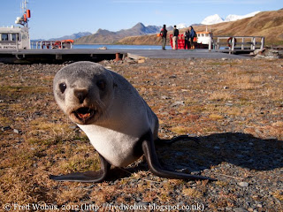
Fur seal at Grytviken jetty
Cook wrote in his journal that South Georgia was "not worth the discovery" and these were lands "Doomed by nature to perpetual frigidness". He proved to be wrong on both counts. Firstly, he made notes on the abundant wildlife on the island, which did not go unnoticed at a time when North Atlantic whaling and sealing grounds were already showing signs of depletion. The first sealers arrived in 1786 to hunt fur seals and around 1800 no less than 112,000 pelts were taken in a single season. Fur seals had evolved without human contact and show no fear when approached and can easily be killed. Millions were slaughtered on an industrial scale. In 1894 whalers joined the gold rush in South Georgia. Whaling stations were established by Norwegian whaling captains from 1904. The epic slaughter of whales in the Southern Ocean began and it reached a deadly crescendo in 1925 when nearly 8000 whales (mostly fin whales) were taken in a single season. The boom was short-lived and dwindling whale stocks forced the closure of most shore-based stations by the 1930s. Whaling briefly resumed after the war when Japanese and Soviet factory ships joined the race for easy profits but by 1965 it was all over. The mechanised slaughter had murdered entire species of whales and seals to the brink of extinction. This questionable industry had become a victim of it own "success". The whales had gone. We saw one lonesome blow of a Southern Right Whale in the distance during 2 days in Cumberland Bay. A shocking observation compared to the early days when one could "walk across Cumberland Bay on their backs" and they have not yet returned. Only the fur seals have managed to successfully rebound into the ecological niche left vacant by the great whales. Their numbers are on the up and South Georgia, now mostly deserted by man, is once again left to be seal country.


Captain cook had also been wrong (or just unlucky) on his second assessment of South Georgia. While howling snow storms and ferocious catabatic hurricanes can swoop down from the mountains at a moment's notice, the day of our visit was graced by blue sky and sunshine. I woke up to a stunning sunrise, which bathed the snowy peaks of the central Allardyce mountain range in a soft, orange Alpenglow. After breakfast we were welcomed to South Georgia by Kieran, a government official stationed at K.E.P., who gave the visitor's briefing. He stressed once again the importance of biosecurity - safeguards against the accidental intruduction of alien species to the fragile island ecosystem. The local government had already spent over 1.5 million pounds on eliminating brown rats which are lethal to the ground-nesting sea birds. Several sectors of the island had been declared rat-free after the world's most extensive rat eradication programme. While the rats originated from early sailing vessels and whale boats, a modern-day visitor is more likely to import seeds, spores or viruses that hitchhike on footwear or velcro strips. We were even asked not to rest our bags on certain types of mosses and grasses, which are potentially vunerable to foreign microbes.


Whaling ship at Grytviken
We had looked forward to mooring up alongside the jetty at K.E.P. from where it's convenient to walk to many of the popular tourist spots. But our berth was still occupied by the Dutch cruise ship 'Plancius' which had limped into port on 11th April with partial engine failure. The 70 stranded passengers plus hotel staff had already been evacuated to Montevideo. We saw the relief vessel 'Ushuaia' leaving port 2 days ago while conducting a CTD survey of Cumberland Bay. The 89-metre cruise ship and a tugboat were still berthed at K.E.P. however, so we dropped anchor instead and used the cargo tender to ferry people and goods ashore.


The cargo tender took us to the old Norwegian whaling station Grytviken, meaning "Pot Bay", just across from K.E.P. Grytviken was the first of the shored-based whale processing plants to be founded on South Georgia in 1904. It was the last to be closed in 1965 and is now the only remaining one open to tousists. A young fur seal hissed and barked at us as we stepped on to the beach to visit the abandoned station. Recently a lot of the old buildings had been dismantled for the dangers posed by asbestos and metal roof sheets that became dislodged in hurricane winds. The site is still crammed with the rusting remains of steam-powered exploitation. The old whaling ship "Petrel" now lies half-beached next to the jetty. As a poignat reminder its harpoon cannon is still mounted on the bow, aimed blankly towards the mountains.


Fred at Shackleton's grave
The nutrient-rich waters south of the Polar Front put South Georgia on the map for whaling and sealing, but for all its remoteness the island is also inextricably linked with human endevour and exploration. Of all the explorers that came and went it is the name of Sir Ernest Shackleton that stands out as a giant amongst men. He is connected to the island up to the present day not just by how he once arrived, but also because he is one of those that stayed. During the 1914-1916 British Imperial Trans-Antarctic expedition Shackleton's ship, the "Endurance", had been crushed in the pack ice forcing him and his men to trek northwards over the ice before escaping in small boats to Elephant Island. Shackleton was determined to resue his men, so he left his "right hand man" Frank Wild and 21 others to winter on Elephant Island where they survived in a shelter built from upturned boats. The remaining six men, including Shackleton himself and his navigator Frank Worsley got into the 9m long open boat "James Caird" on 24 April 1916 to sail to South Georgia from where a rescue mission would be organised. Their journey which led them through ferocious storms across 800 miles of open ocean and over 4000-feet high glaciers of South Georgia has been described as one of the greatest adventures in polar history. On 19 May a dishevelled figure staggered into the station manager's house at Stromness harbour to tell his tale and organise a relief vessel - his men would be safe.


Fur seal at King Edward Point
Shackleton organised another Antarctic expedition on the "Quest" in 1921-1922 together with Frank Wild and several members of the Endurance expedition. However, on 5th January 1922 Shackleton suffered a heart attack aboard the Quest and he died, thereby effectively ending the expedition. His wife asked for his body to be interred at South Georgia, as she sensed that this is what he would have wanted. I visited Shackleton's grave in a small cemetery not far from the whaler's church of Grytviken. Of all the traditionally east-facing graves of whalers and seamen, his grave is the only one that faces south. Recently an urn containing the ashes of Frank Wild was rediscovered and transferred to the same cemetery at a spot to the right of Shackleton. A new head stone was carved and it reads "Shackleton's Right hand Man". One can't help but feel that this is what Wild would have wanted too.


Vickers gun
After the hero worship at Grytviken we set out on a walk over the hills in search of scenery and wildlife. The walk over Dartmoor-style moorland took us past various military relicts. We came across an old Vickers gun placement and a little lookout hut that was riddled in bullet holes. At the bottom of a ravine we spotted the wreck of an argentine helicopter that had crashed during the 1982 conflict. The terrain rose higher and offered breath-taking views over Cumberland Bay. The mountains of the Allardyce Range and its glaciers gleamed in the mid-day sun. From the summit ridge the ground steeply dropped away and opened up to a vast valley. It was the fluvial plain of a river leading into the sea from meltwater lakes that were fed by the mountain's countless glaciers. This wasn't just any river. We had arrived at "Penguin River".


Penguin River valley and Allardyce mountain range


King penguins
Penguin River may not be the official name of the site, and even so it should better have been named Seal River. Before we reached the gravel beds down in the flood plains we had to run the gauntlet of hundreds of fur seals hidden in the tussock grass. Thankfully each of them let us know about their presence with noisy hollering, barking and hissing. It felt like a scene from Indiana Jones - jumping from grassy mound to mound until we had reached a small gravel island in the middle of the river. This is where we camped out for a while, bodies pressed close to the ground and watched a family of King penguins. It seemed the river did deserve the name after all. And so did the penguins - their brilliant white and black coat with dazzling splashes of orange gave them the regal demeanor that their name suggested.


Preying skua stalks penguins
In the midst of the king penguin group were several juveniles in grey plumage. These scruffy fluff-balls were called them 'Oakum Boys' by early sailors for their resemblence to the oily fibres used to caulk wooden ships. Indeed they look so different from their tuxedoed parents that they were originally classified as their own species of "whoolly penguin". Another not so obvious visitor to the penguin family was a Skua - a bird known to snatch an unattended egg or chick at a moment's notice. The skua was sitting right amongst the adults and juveniles, but surely the woolly ones were old enough already to defend theselves against a skua. The secret was lifted a while later when a squawking chick emerged from a feathery fold of an adult where it had been sitting on its feet. It was no bigger than a couple of inches and seemed utterly helpless in this world. The presence of the chick now fully explained the intentions of the skua, which was simply waiting on the sidelines for the briefest of moments to snatch the chick should its parents turn away for a second. It is not unusual to see two generations of juvenile king penguins together. In fact it is completely normal - the 18 month breeding cycle of this species is staggered - while older juveniles are still being looked after by some parents the next generation may already be on its way.

King penguins with chick


Male elephant seals
All around the river bank there were fur seals dozing in the sun or playing in the river. They are fast movers, despite their waddling hopping motion on land, they come into their own in water. Young seals were pupoising through the water as fast as I could run. Thankfully their aggressive gestures were nothing more than a bluff. Everytime I returned the bluff by growling at them or stretching out my leg to shove my boots in their general direction they whinced and retreated briefly. The trek through the tussock grass became a whole lot more interesting when Gaz waved me over and motioned to be quiet. He had stumbled upon two fully grown elephant seal bulls that were wallowing in a mud pit camouflaged by the tussock. The one facing up slowly woke up from its slumber and made the most primeval noises. In front of us two times 2 tons of blubber and they were groggily waking up from their snooze in the sun. These things are a formidable sight and I could not for the life of me work out how they had heaved their bodies out of the sea without breaking several laws of physics. We didn't get any closer and slowly retreated backwards which made the elephant seals happy again and their grunting eventually stopped.

Young fur seals

Female elephant seals
The beach on the seawardside of penguin river was home to thousands more fur seals and I got to see the female elephant seals as well. The females congregated in small groups, and generally hissed and barked if anyone strayed too close. They are much smaller than the bulls but I didn't want to call their bluff despite their speed on land being much slower than of a fur seal. Elephant seals are "true seals" that cannot point their hind flippers forward to hop along liek dogs. That makes them better adapted under water, but slower on land. Apart from being littered with seals the beach was also covered with whale bones from a bygone era of undiscriminate slaughter. After decades of weathering in the surf and sun they looked like driftwood and it was mostly their characteristic shape which gave them away as bones. A highlight of the whale bones was the hip bone of a very large individual, possibly a blue or fin whale which, when I stood next to it for scale, allowed a vague guess at the enormeous size of its original owner.


Fred with a giant whale hip bone
The walk from Grytviken, steeped in grisly history, to Penguin river, teeming with wildlife, has been the unrivalled highlight of my trip down south so far. The open valley where vividly green grass meets the glistening white of the glacier. The wind blown summits in the distance which pierce into a cobalt-blue sky. These awe-inspiring colours combined with the natural wonders of seals, penguins and their predators had placed South Georgia into the Top 10 of most beautiful places I have ever seen. There will never be a definite winner - how can you compare the natural beauty of a pristine coral reef with the bleak, yet beautiful desolation of a high alpine summit. But South Georgia is now firmly in my Top 10 - just next to Komodo Island, Lembeh Straits, Fijian beaches or the Mont Blanc range of the French-Italian Alps to name but a few.


Rusting wrecks at Grytviken
On my return to Grytviken I also visited the museum, church and the post office which are all worthy of a mention in their own right. But I thought I'd leave it at magical wildlife encounters and the history of human endevour on these shores, while keeping my memory of the present human occupation for another time.


The James Clark Ross weighed anchor at King Edward Point and left Cumberland at nightfall to brave the large ocean swell on the long journey back to the Falkland Islands. Our ETA at Stanley is on the 24th April. Plenty of time to cast my mind back to the magic at Penguin River.


(The books "South Georgia, Antartic Sanctuary" by Kevin Schafer, Coach
House Publications, 2006 and "Shackleton" by Roland Huntford, Abacus,
1985 helped in compiling some of the historical information in this article)

Thursday 19 April 2012

Day 23 Cumberland Bay

Cumberland Bay, South Georgia
Wednesday, 18th April 2012. While the weather was pretty spectacular yesterday in bringing to life the icy splendour of the glacier in Royal Bay, it had a lot more up its sleeve when we got to Cumberland Bay at South Georgia. The bay is actually two bays, or more precisely two fjords cutting deep into the island. Most of the clouds that had lingered over the breathtaking mountain scenery at first light had now disappeared. We had arrived just in time for a day of glorious blue sky and sunshine. At the end of the fjord we were treated again to a dazzling display of sunlight bouncing off a gleaming white glacier tongue. Deeply fissured columns of ice lit up in all shades of aquamarine, like a giant jewel reaching out to sea. I would have loved to see the glacier calve that day, but nothing of the sort happened. It was only the light that changed constantly.

Glacier meets ocean
Throughout the day we conducted a CTD survey of the waters inside the fjord and at its mouth (measuring Conductivity/Temperature/Ddepth to calculate temperature/salinity/density of water). The depth was reasonably shallow, between 130 and 260m, so each cast was done in fairly rapid progression. Down, up, move a bit, down, up, down, move a bit and so on. The ship's path prescribed a transect from the start of glacier out to sea for the first part and then a cross-section over the mouth of the fjord in the second part.
View towards King Edward Point

CTD deployment
The measurements of temperature and salinity revealed some interesting, if not unexpected, features. At the surface of the water is a distinct layer of about 10m thickness which is noticably fresher (less saline) than the deeper waters. This brought about some interesting problems. As the ship was moving the fresh surface layer could be seen on the underway salinity sampler. As it's mounted on the bow of the ship it measures the first bit of new water that the ship pierces into when it's steaming along. But every time as we came to a stop, the salinity rose again to that of normal sea water. What was going on? Well, the ship has powerful propellers which when on reverse thrust produce huge whirls of turbulence that act as brakes and maneuver it into an exact position. But the thrusters were also destroying the surface layer of fresher glacial outflow water. As we came to a stop, the special surface layer was already nicely blended into the deeper ocean water, and the original salinity signature was gone in the exact patch of water around the ship where we were about to do our measurements. As a result, the captain adopted a much gentler approach to stopping the ship at the designated station. We approach the station slower and the reverse trhuster were engaged earlier and then turned off just before the target position. The ship then gently drifted into a patch of undisturbed water where we could get some excellent measurements of the waters within the fjord.

Fred at the CTD control terminal
During the day I had the chance to take the helm at the CTD station on the science deck and look after the instruments in the CTD enclosure on the work deck. On the control terminal I could see the data streaming in via the cable in real time. I could observe the different layers of water in the fjord as the probe descended. The actual winch is operated by experienced crew, but the CTD "driver" checks the depth and gauges the distance to the sea bed to give precise instructions to the winch operator. It's the aim on each cast to send the CTD to within 10m of the bottom. While the winch operator only knows how much cable has been paid out, the CTD operator can see the output from an echo-sounder mounted on the the CTD. This echo-sounder, called the altimeter, measures how far the bottom of the CTD frame is off the bottom, so the winch can be stopped in time. It is considered pretty bad form to bring up a broken and dented CTD that is covered in mud.


When I wasn't at the CTD control terminal, I was on the work deck and checked the instruments every time they cam back on board. The currents meters mounted on the frame don't have their own data cable going back to the ship, so it must be plugged back into the ship-board powersupply every time it cames back up. So the time between station gives time for recharging but also for downloading and archiving of the data from the current meter. Once processed this data can reveal how fast the different water masses are moving - useful information to reveal the dynamics of the flows within the fjord.

After the CTD transect there was still some time for taking more sediment cores before the weather moved in. I had a great day admiring the scenery and they say that good things comes to those who wait, but good things also don't last long. As the sun was setting, the wind had already whipped up to a tidy 40 knots. The previously calm waters started to boil, big waves with white caps rolled in, the clouds returned and before long the magic scenery of Cumberland Bay was hidden once again behind fog and sideways rain showers. But it was good while
it lasted!

Day 22 Royal Bay

The JCR arrives in Royal Bay, South Georgia
Glacier-watch on the monkey island
Royal Bay glacier
Royal Bay glacier
King penguin colony
Tuesday, 17th April 2012. The Southern Ocean isn't one to give up its secrets easily; its wonders are mostly hidden under a cloak of a mile-deep ocean or veiled behind a curtain of fog. But when the weather turns at the right moment, it certainly lets you in on a few wonders. And one of those was waiting for us today...

Our ship, the James Clark Ross, drew closer to the north-eastern corner of South Georgia this morning. Under the gaze of scientists and crew who had gathered on the monkey island (the 'roof' of the bridge) we pulled into Royal Bay. We could not have arrived at a better time, as the shrouds of mist slowly drifted off and gave way to glorious sunshine. Royal Bay is dominated at one end by a glacier pouring rivers of ice into the ocean. The sunshine danced around the glacier tongue and illuminated the frozen river colouring it gleaming white and incandescent shades of blue.

Vast snow fields rose up from the glacier and flanked the base of steep, jagged mountains. The terrain rose dramatically to a series of snow-capped peaks. The snow accentuated the three-dimensional structure of the local geology by highlighting the stratification. The clouds shrouding the summits parted for a few moments at a time only. It was easy to get carried away taking more and more photographs as the light changed every minute.

The keen bird watchers in our group had brought telescopes and spotting scopes. The ship was now stable in the calm waters of the bay so tripods could be mounted on deck. The added optics were excellent to scan the coastline for wildlife. I was called over to a spotting scope that was pre-focussed on the eastern beach. First I saw just a couple of white specks on the beach. "Pan to the right", Hugh called, when I didn't quite realise what I was looking at. And then it dawned on me - there wasn't just a couple of specks, there was hundreds. "Where does it end?" I asked. "Just keep panning right" was the answer. There was thousands, possibly tens of thousands. The entire beach was literally carpeted in KING PENGUINS!!! However, we weren't close enough to get a really good look and even the high magnification of the spotting scope couldn't bring out any details. My camera was even less able to capture the scene - but what I was able to take in was the sheer vastness of the penguin colony.

We had come to Royal Bay to sediment cores. The coring for the day was very successful and the wet lab soon filled up with lots of tubes full of mud. The sediments in Royal Bay are darker as they are of glacial origin. The scraping and scouring of the flowing ice sends plumes of finely ground minerals into the bay. The layering of the deposits gives clues to the life of the glacier over the past thousands of years. The paleo team hopes to canalyse the cores and find how the glacier changed in the past in order to find clues as to how it might change in the future. With temperatures and sea levels rising around the globe there isn't a corner of the planet that isn't affected by the changing climate. Glaciers, whose volume delicately depends on the prevailing conditions, are very useful in the study of climate change. Especially when the sediment cores can take us thousands of years into the past.

We are now planning a CTD survey for more studies of the glaciers on South Georgia, so we should stay around this magical island for a little longer....

Wednesday 18 April 2012

Day 21 Somewhere off South Georgia

The coastline of South Georgia in the distance
Fin whales blow in the distance
Fin whales
Monday, 16th April 2012. The day after our amazing trip to Bird Island was taken up by the coring team who took lots more samples of layers and layers of glorious mud from the sea floor. The sediments are full of diatoms, tiny little planktonic algae, which give the sedimentary layer a slight green tinge. The team had been hoping to find more carbonate-based sediments, but siliceous diatom ooze is all they got. Lots and lots of it.

While the corers were busy, I had time to scan the horizon. When the curtain of fog lifted the South Georgia coastline popped into view every so often. Through the mist I could make out a jagged mountain range of snow-capped peaks with glaciers carving through the steep and rocky terrain. I'm looking forward to seeing more of South Georgia as we'll be doing more science in the direct vicinity of the island over the next few days.

The time gazing at the horizon wasn't in vain. A pod of whales cruised past the ship some distance away. Again, they came barely to within binocular range and on camera it's mainly the blow that shows up with the occasional flash of an arching back. I'm getting better at telling the species of whale by their blow and the shape of their back and dorsal fin. These were fin whales, a large species of rorqual whales, that grows up to 27m in length. Fin whales are similar in shape to blue whales, but have a more pronounced dorsal fin that gives the species its name. Three of four animals travelled together at considerable speed, blowing and diving in regular intervals. The spectacle didn't last long. Fin whales are fast swimmers and before long they were gone again.

Monday 16 April 2012

Day 20 Bird Island

Bird Island - a haven for antarctic and sub-antarctic wildlife.

Bird Island just off South Georgia
Sunday, 15th April 2012. At four minutes past 6 o'clock - and for the first time for nearly three weeks - the ship's starboard anchor was let go half a mile off Jordan Cove at Bird Island. The science crew assembled in the cargo hold, where we otherwise meet for circuit training, to load up palettes of supplies for the research station on the island. The crates of fresh vegetables, frozen meat, beer, parcels, letters etc. would be eagerly awaited by the station staff and our visit would be the last call until the arrival of the southern spring in October.
The JCR off Bird Island
Bird Island is an Antarctic Island located south of the Antarctic Convergence(*) at about 54°S, 38°W in the deep south of the Atlantic Ocean. A 500m wide strait separates it from the island of South Georgia - the "mainland", out of the perspective of the base inhabitants, from where the island is administered by the Government of South Georgia and the South Sandwich Islands. The island was first sighted by Captain Cook in 1775, who named it Bird Island "on account of the vast numbers [of birds] that were upon it". Although visited by sealers and whalers in the late 19th century it wasn't until 1957 that scientists first came to the island to study the bird and seal population. A base was established and occupied intermittently by summer parties until 1982, after which a permanent presence was established. The base has been manned continuously from 22 Sep 1982 to the present day. During the (southern) winter from April to October a party of 4 personell remains on the island while up to 10 researchers, research assistants and technicians inhabit the base during the summer. The base is operated by the British Antarctic Survey whose scientists conduct a wide range of biological research on seabirds and seals as well as maintaining a long term monitoring programme to study the ecosystem dynamics of the southern ocean.

The cargo tender of the JCR
Our supply run to the island was carried out using the ship's cargo tender, which is stowed on the fore deck when not in use. The tender is a small landing craft with an open deck cargo hold the size of a shipping container. It was lifted off the deck by the ship's onboard cranes and put into the water. A rigid inflatable Humber was also in the water for safety reasons - the Humber is more maneuverable to fish anything (or anyone) out of the water that falls over the side during boarding. I was in the first wave of scientists to go ashore. This would be the first time in 3 weeks that I got off the ship and I finally stood on solid ground again on the newly constructed jetty. Two scaffolders has been especially dispatched to the island for this job and they had only finished building it two days ago. They had done a great job and nothing moved or creaked as the cargo tender moored up. More surprisingly the ground didn't keep on moving once I was back on terra firma. It was a great feeling to be on land again, and thankfully I didn't get any land legs. Which was nice.

The research station at Bird Island
The research station is located on Freshwater Beach at the end of Jordan Cove. A metal walkway leads from the jetty up to the buildings - a generator shed, a storage and workshop building and the main building with living quarters, laboratories and offices. The base commander received us with a broad smile - I suppose one needs a perpetually cheerful attitude in such a remote place. Or was it because we had brought lots of goodies? He apologised that the island was currently "bereft of wild life" (his exact words!). Well, that was his assessment, but I had already had several wildlife heart attacks by that point. All the way into Jordan Cove the cargo tender had passed rock after rock littered with seals. Seals were in the water to greet us on the jetty. There were seals everywhere amongst the tussock grass around the station. There were seals all over the beach. It must have been hundreds! Not only seals - there were Gentoo penguins waddling around on the beach. The air above us was swarming with giant petrels and albatrosses. Not exactly bereft in my books.
 
Fred at the jetty of Bird Island research station
Only later, until I had seen the photographs inside the station, did I realise what it means when the island is actually teeming with wildlife. During the seal breeding season (around Christmas time) there aren't just hundreds of seals on the beach - there are thousands, literally thousands. The local species is the Antarctic Fur Seal, which had been driven to the brink of extinction by hunters who shot millions of them for their fur and blubber. When the seals were finally granted protection the global population had crashed to just 5,000 animals - nowadays that's how many come to Bird Island alone as the species is currently stable and the population is growing. Their numbers bounced back as soon as the slaughter stopped, but even despite protection they haven't recovered to pre-hunting levels the population as seals face continuing pressures from pollution and resource competition.

Giant petrels
The unloading of the boxes didn't take too long. But there was the small issue of biosecurity first. Every cabbage, papper or broccoli was carefully inspected for any bugs, insects and otherwise unwanted wildlife. The accidental transfer of alien species can wreak havoc on the ecosystem of remote island where life has evolved in the absence of such threats. The South Gorgia government has strict measures in place to ensure that Bird Island would not be colonised by alien invaders and their priority is on the island staying rat free - an invasion of land predators would quickly kill of the ground nesting bird population. While the cargo tender was checked for hitchikers, every visitor also had to scrub their boots with disinfectant check their clothing clothing. And just as we had to hoover out our pockets and pick bits off any velcro strips the vegetables had to be thoroughly checked too. Several weeks ago two earwigs had achieved fame in the local newspaper after they'd been discovered in a delivery of vegetables to South Georgia from the Falkland Islands. At Kind Edward Point a special facility had been constructed to oversee the biosecurity inspection of any imports to the islands. At Bird Island this was done in the kitchen. While not every cauliflower looked too healthy and many a pepper was bruised and marginal for human consumption none of them had any alien visitors hidden within.

Young fur seals
While the vegetables were being checked, the bulk of the cargo operation was the removal of the old scaffolding which was waiting to be taken off the island. It wasn't only the jetty replacement that left tons of rusting metal to be disposed off, but a new seal observation platform had also been constructed. The raised walkway on the next beach was high enough that seals couldn't get on it, so it could be used to monitor the animals from a safe distance. Fur seals are feisty creatures, and they can move quickly. Unlike true seals they can turn their hind flippers forward and gallop in a way similar to a dog with broken legs - just faster, Much faster. Apparently, a fur seal can outrun a human on dry land, and I wasn't in the mood to find out. On the beach I mainly encountered the juveniles which readily approach humans first, but then groan and howl at anyone getting too close. The young ones, however, usually stop just in front of you and keep on barking. I am told that adult bulls won't display any such lack of courage. They will happily charge a two-legged intruder and occasionally even take a bite or two. I heard reports of people being bitten in the hand and someone had a chunk of flesh taken out of his calf after getting a bit too close.


Antarctic fur seal
True to its name, the island was teeming with bird life. A rock shag followed us from the sea to the island when we first arrived. Once there I saw giant petrels sitting on the beach and brown skuas could be seen around the living quarters possibly looking for food scraps. Albatrosses were patrolling the skies everywhere around the island. I had read that they breed on Bird Island. The steep slopes of the hills surrounding the station are covered in green clumps of tussack grass and amongst them I could pick out pairs of white dots. These dots were wandering albatrosses and their chicks. These magnificant birds breed on the ground high up on the grassy slopes. Unfortunately there wasn't time for us to walk up to the nests. One of our scientists from the second wave of visitors did manage to walk up to the albatrosses though. Presently the adults were rearing their chicks, who sported a white fluffy outfit and were already of considerable size. The huge birds nest on the ground, which is what makes them so vulnerable to land predators like rats or cats. But on Bird Island there are no such threats other than occasional human visitors who count or ring them, or simply take photographs. From my colleagues photos I could finally gauge the size of a wandering albatross. Standing upright an adult wandering albatross would reach up to my waist(!). With their beaks stretched upwards they could reach even higher and peck my chest if they wanted to (and I'm 6'1" tall!). I would struggle to reach around their body with both arms and link hands. And this doesn't even consider their wing span which is up to 3.5m. They are truly formidable in size. It is such a shame that I didn't have the opportunity to walk up to the colony myself. So I will have to leave a direct comparison with my own height to a later date.


Giant petrels
One of the people who'd definitely have the chance to see the albatrosses over and over again is the resident zoological assistant. She is responsible for monitoring the albatross population and keeping a record of each bird breeding on the island. Each individual is identified by a number on a ring around the leg. The numbers are entered into a database and each year returning birds are observed for their breeding success. The number of chicks is recorded, whether they survived, if they were ringed and what number was assigned to the chicks. An impressive albatross geneology database has been assembled this way. We tested the database by pulling up the record of albatross F39 which we had identified from a photograph taken in mid-flight whilst we were in the Scotia Sea north of the Sourth Orkney Islands. It turned out that this individual had first attempted to breed in 1986 and while trying for almost every year after than only succeeded in 6 of the 27 years since then. To find the reason for such breeding failures is one of the motivations of the monitoring programme. I simply found it astonishing to have encountered an animal, a bird(!), that was possibly older than myself. It is said that there are albatrosses alive today that were ringed when the first seabird researchers came to the island in 1957. They are truly remarkable creatures.

A friendly Gentoo penguin
The other birds under close observation are the resident penguins. Gentoo penguins breed just a few hundreds yards from the station just over the ridge from Freshwater Beach. A rookery of Macaroni penguins is situated on the north-western shore of the island. The shape of penguins foot means they can't be ringed, but their population can still be monitored and studied by other means. Several years ago a study on the evolution of penguins required the collection of their eyeballs. Yes, the eyes of dead penguins! And no animal dies unnoticed on this island. Within minutes of a living being keeling over it will be devoured by skuas, petrels and other predators. The then resident penguin researcher had to watch the colonies closely to wait for the exact moment a penguin had come to the end of its natural life. As soon as it was dead, the researcher would then run over to the deceased animal and remove the eyeballs. Apparently a tea spoon was the tool of choice for this particular part of the research. I forgot to ask whether it was a designated teaspoon....

I had the joy of meeting with local Gentoo penguins who were very much alive. While crouching low to the ground I observed a Gentoo on the beach near the jetty. After a while it even came over and investigated me. The penguin was now within an arms reach! For minutes we were looking at each other, watching each others movements (I stood still, too scared to breathe actually). I was enchanted - It is those moments of intimate eye contact that wild life encounters take on a magical touch and transcend the all too common ticksheet approach to wildlife spotting. A penguin had actually popped over to check me out. And it let me watch and take pictures. The reflective camera lens seemd to be of particular interest - It waddled ever close to get a better look. Maybe at itself? Who knows. It would have been great to get to know the little fellow even better.

I had a wonderful day on Bird Island, and would like to thank the lovely station staff who welcomed us and showed us around. I know we brought chocolate, cheese, wine and earwig-free broccoli, but the station is still their home and workplace. Other than not getting a chance to see the albatrosses in person, I only really regret that, over the early morning start, I forgot to take Pingu, my mascot, to Bird Island. The little fellow could have met its real-life cousins.

Thanks to Mike Gloistein, Hugh Venables and Robin Pasqual for additional research and ideas for this article.


(*) The Antarctic Convergence is a circumpolar region whose boundary undulates between 50° and 60° south. It is defined by a belt of noticable changes in water temperature and sometimes marked by a localised belt of fog or mist - where the warm saline surface currents coming south from teh tropics meet the cold, denser and less saline water flowing north from the Antarctic. Where the two current systems converge the mixing of the conflicting water masses provides a rich environment for plankton growth that fuels the food chain and supports an abundance of wildlife. South Georgia lies south of the Convergence and is therefore biologically speaking an Antarctic Island, unlike the Falklands which lie north of the boundary. (Information abridged from "Antarctica - A guide to wildelife", by Tony Soper, 2004, Bradt Travel Guides UK)